Conjure an image of Tokyo in your mind and I bet it looks something like Harajuku, a district brimming with neon signage, konbini (convenience stores), anime-inspired shops, and crowds and crowds of people — a sea of cosplay and candy, with shopping, nightlife, and skyscrapers galore. It’s an image befitting one of the most densely populated cities in the world, a center of culture and creativity, a place of noise and action.
But that’s not the whole story. If you know where to look, you can find gateways between worlds: On one side, the Tokyo of endless bustle, while on the other, a pocket of greenspace that will stun you with its stillness as profoundly as Harajuku will with its dynamism. Whether you fancy quiet time with a book under expansive canopies, a heart-pumping hike, shinrinyoku (“forest bathing”), or a tranquil boat ride, Tokyo offers an escape for those who seek it.
With COVID restrictions lifted and Japan’s borders finally open to tourists, now is the perfect time to explore places beyond the regular tourist sites and the glitz of this bustling city. Here are my top recommendations for an escape into nature in Tokyo.
The concept of ki (気) is vital to the Japanese consciousness. It is the life force; Westerners might be more familiar with the term chi, which is how the Chinese refer to it. One’s well-being is determined by one’s ki, and perhaps the best place in Tokyo to encounter this life force, in all its powerful stillness, is at the Meiji Jingu shrine in central Tokyo.
Given its proximity to Shinjuku — the busiest subway station in the world, according to Guinness World Records — the calm majesty you experience when you pass through Meiji Jingu’s tall wooden torii gate will be pleasantly jarring. But is it a park? Is it a shrine? Is it a forest? The answer is “all of the above,” but most of all this is where you’ll find yourself wanting to slow down to take it all in.
Spread across 175 acres, the shrine dedicated to Emperor Meiji and Empress Shoken is accessed via a path through a manicured forest of more than 100,000 trees. Halfway in, you’ll be flanked on either side by large barrels of o-sake (yes, that’s the respectable way to refer to sake, Japan’s beloved alcoholic beverage), which are offerings to the shrine from across Japan. Among them are also barrels of wine from different countries.
Within this generous blanket of calm, visitors will experience their own shift to slowness. This is what it means to visit Tokyo’s hidden green spaces: Be one with yourself, and with nature, amid the bustle.
.map * {
font-family: sans-serif !important;
}
.info-window-link {
display: block;
margin-top: 10px;
padding: 3px 10px;
border-radius: 3px;
background-color: #0099ff;
color: white !important;
font-size: 12px;
text-align: center;
}
.info-window-link:hover {
text-decoration: none;
}
var _icons = {
red: {
url: ‘https://travelstoke.s3.amazonaws.com/assets/images/precise_marker_2x.png’,
size: { width: 22.8, height: 35.4 },
anchor: { x: 11.4, y: 35.4 }
},
orange: {
url: ‘https://travelstoke.s3.amazonaws.com/assets/images/precise_marker_orange_2x.png’,
size: { width: 22.8, height: 35.4 },
anchor: { x: 11.4, y: 35.4 }
},
yellow: {
url: ‘https://travelstoke.s3.amazonaws.com/assets/images/precise_marker_yellow_2x.png’,
size: { width: 22.8, height: 35.4 },
anchor: { x: 11.4, y: 35.4 }
}
};
var _styles = {
travelstoke: [
{
featureType: ‘administrative’,
elementType: ‘geometry.stroke’,
stylers: [{ color: ‘#999999’ }]
},
{
featureType: ‘landscape.natural.terrain’,
elementType: ‘geometry’,
stylers: [{ visibility: ‘off’ }]
},
{
featureType: ‘poi.business’,
elementType: ‘all’,
stylers: [{ visibility: ‘off’ }]
},
{
featureType: ‘road’,
elementType: ‘geometry.stroke’,
stylers: [{ color: ‘#ffffff’ }]
},
{
featureType: ‘water’,
elementType: ‘geometry’,
stylers: [{ color: ‘#53acce’ }]
}
],
desert: [{“elementType”:”labels”,”stylers”:[{“visibility”:”off”},{“color”:”#f49f53″}]},{“featureType”:”landscape”,”stylers”:[{“color”:”#f9ddc5″},{“lightness”:-7}]},{“featureType”:”road”,”stylers”:[{“color”:”#813033″},{“lightness”:43}]},{“featureType”:”poi.business”,”stylers”:[{“color”:”#645c20″},{“lightness”:38}]},{“featureType”:”water”,”stylers”:[{“color”:”#1994bf”},{“saturation”:-69},{“gamma”:0.99},{“lightness”:43}]},{“featureType”:”road.local”,”elementType”:”geometry.fill”,”stylers”:[{“color”:”#f19f53″},{“weight”:1.3},{“visibility”:”on”},{“lightness”:16}]},{“featureType”:”poi.business”},{“featureType”:”poi.park”,”stylers”:[{“color”:”#645c20″},{“lightness”:39}]},{“featureType”:”poi.school”,”stylers”:[{“color”:”#a95521″},{“lightness”:35}]},{},{“featureType”:”poi.medical”,”elementType”:”geometry.fill”,”stylers”:[{“color”:”#813033″},{“lightness”:38},{“visibility”:”off”}]},{},{},{},{},{},{},{},{},{},{},{},{“elementType”:”labels”},{“featureType”:”poi.sports_complex”,”stylers”:[{“color”:”#9e5916″},{“lightness”:32}]},{},{“featureType”:”poi.government”,”stylers”:[{“color”:”#9e5916″},{“lightness”:46}]},{“featureType”:”transit.station”,”stylers”:[{“visibility”:”off”}]},{“featureType”:”transit.line”,”stylers”:[{“color”:”#813033″},{“lightness”:22}]},{“featureType”:”transit”,”stylers”:[{“lightness”:38}]},{“featureType”:”road.local”,”elementType”:”geometry.stroke”,”stylers”:[{“color”:”#f19f53″},{“lightness”:-10}]},{},{},{}]
};
window.addEventListener(‘load’, function() {
console.log(‘test’);
jQuery(document).ready(function($) {
var boundPadding;
var id = ‘map-638afd0f6d70a’;
var atts = {“lat”:”35.68599074522515″,”lng”:”139.699718794694″,”zoom”:”13″};
var markers = [{“lat”:”35.6774085671385″,”lng”:”139.69943318835493″,”title”:”Meiji Jingu”},{“lat”:”35.69023361119282″,”lng”:”139.70063262126348″,”title”:”Shinjuku Station”}];
var map = new google.maps.Map(document.getElementById(id), {
mapTypeId: google.maps.MapTypeId.ROADMAP,
disableDefaultUI: true,
zoomControl: true,
scrollwheel: false,
zoomControlOptions: {
style: google.maps.ZoomControlStyle.LARGE,
position: google.maps.ControlPosition.LEFT_CENTER
}
});
if (atts.style && _styles[atts.style])
map.setOptions({ styles: _styles[atts.style] });
if (atts.padding !== undefined)
boundPadding = parseInt(atts.padding);
var mapBounds;
if (atts.lat !== undefined && atts.lng !== undefined) {
// Use lat and lng if provided
map.setCenter({ lat: parseFloat(atts.lat), lng: parseFloat(atts.lng) });
} else if (markers && markers.length) {
if (markers.length === 1) {
// Use lat lng from first marker if only 1 provided
map.setCenter({ lat: parseFloat(markers[0].lat), lng: parseFloat(markers[0].lng) });
} else {
// With multiple markers create a boundry that includes all of them
mapBounds = new google.maps.LatLngBounds();
}
}
var labels = ‘ABCDEFGHIJKLMNOPQRSTUVWXYZ’;
var labelIndex = 0;
if(atts.offset !== undefined) {
labelIndex = parseInt(atts.offset);
}
var infoWindow = new google.maps.InfoWindow({ content: ” });
var openInfoWindow = function(marker, target) {
var info = $(‘
$(‘
if (marker.scroll_to) {
$(‘‘, {
class: ‘info-window-link’,
href: ‘#’ + marker.scroll_to,
}).append(‘Jump To’).appendTo(info);
}
infoWindow.setContent(info[0].outerHTML);
infoWindow.open({
anchor: target,
map: map,
shouldFocus: false
})
};
$(‘#’ + id).on(‘click’, ‘.info-window-link’, function(e) {
console.log(‘info window’);
e.preventDefault();
var target = $(e.target).attr(‘href’);
$(‘html, body’).animate({ scrollTop: $(target).offset().top – 55 }, 1000);
});
for (var i = 0; i < markers.length; i++) {
var marker = markers[i];
if (marker.lat !== undefined && marker.lng !== undefined) {
var markerObject = {
map: map,
position: { lat: parseFloat(marker.lat), lng: parseFloat(marker.lng) },
animation: google.maps.Animation.DROP,
locationId: i,
}
if(atts.ordered !== undefined) {
if(atts.numbered !== undefined) {
number = labelIndex = labelIndex + 1;
markerObject.label = number.toString();
} else {
markerObject.label = labels[labelIndex++ % labels.length];
}
}
if(marker.icon !== undefined) {
markerObject.icon = marker.icon;
}
var mapMarker = new google.maps.Marker(markerObject);
if (mapBounds) mapBounds.extend(mapMarker.getPosition());
if (marker.title) {
var infowindow = new google.maps.InfoWindow({ content: marker.title });
if (markers.length === 1) {
setTimeout(function() {
openInfoWindow(marker, mapMarker);
}, 1200);
}
google.maps.event.addListener(mapMarker, 'click', function() {
openInfoWindow(markers[this.locationId], this);
});
}
}
}
if (mapBounds) {
map.fitBounds(mapBounds, {top:boundPadding, right:boundPadding, left:boundPadding, bottom:boundPadding});
} else if (atts.zoom) {
map.setZoom(parseInt(atts.zoom));
} else {
map.setZoom(16);
}
});
});
Escape the neon glow and get your heart racing with a hike up Mount Takao. Located in the western part of the city and just an hour’s ride from central Tokyo on the Chuo Line is the base of Takao-san, as it’s reverently called. The base itself is dotted with natural splendors, including a burbling brook — follow the bridge across to a small café for traditional Japanese snacks.
There are several hiking routes up the mountain, but the broad and mostly paved trail #1 is the most popular. (Insider tip: Go during the week when it’s less crowded.) The trail will get your heart rate up, but you’ll also see all the major sites along the way, including Monkey Park and Yakuoin Temple. On a clear day, you’ll have a good view of Mount Fuji, along with a range of other mountain peaks rising to the south of Tokyo.
You may be tempted to hop aboard the cable car to spend more time at the top of the mountain — there are multiple restaurants at the summit serving hot ramen and other treats to reward intrepid hikers — but save it for the way down. You’ll have a view of the forest on either side of the adventurous downslope ride while taking in the stunning panorama of Tokyo. Not to mention that sweet ache in your legs you only get after walking up a mountain.
If you visit between late June and the end of October in 2023, don’t miss Beer Mount, an all-you-can-eat (and drink) summertime feast at the highest beer garden in the city.
.map * {
font-family: sans-serif !important;
}
.info-window-link {
display: block;
margin-top: 10px;
padding: 3px 10px;
border-radius: 3px;
background-color: #0099ff;
color: white !important;
font-size: 12px;
text-align: center;
}
.info-window-link:hover {
text-decoration: none;
}
var _icons = {
red: {
url: ‘https://travelstoke.s3.amazonaws.com/assets/images/precise_marker_2x.png’,
size: { width: 22.8, height: 35.4 },
anchor: { x: 11.4, y: 35.4 }
},
orange: {
url: ‘https://travelstoke.s3.amazonaws.com/assets/images/precise_marker_orange_2x.png’,
size: { width: 22.8, height: 35.4 },
anchor: { x: 11.4, y: 35.4 }
},
yellow: {
url: ‘https://travelstoke.s3.amazonaws.com/assets/images/precise_marker_yellow_2x.png’,
size: { width: 22.8, height: 35.4 },
anchor: { x: 11.4, y: 35.4 }
}
};
var _styles = {
travelstoke: [
{
featureType: ‘administrative’,
elementType: ‘geometry.stroke’,
stylers: [{ color: ‘#999999’ }]
},
{
featureType: ‘landscape.natural.terrain’,
elementType: ‘geometry’,
stylers: [{ visibility: ‘off’ }]
},
{
featureType: ‘poi.business’,
elementType: ‘all’,
stylers: [{ visibility: ‘off’ }]
},
{
featureType: ‘road’,
elementType: ‘geometry.stroke’,
stylers: [{ color: ‘#ffffff’ }]
},
{
featureType: ‘water’,
elementType: ‘geometry’,
stylers: [{ color: ‘#53acce’ }]
}
],
desert: [{“elementType”:”labels”,”stylers”:[{“visibility”:”off”},{“color”:”#f49f53″}]},{“featureType”:”landscape”,”stylers”:[{“color”:”#f9ddc5″},{“lightness”:-7}]},{“featureType”:”road”,”stylers”:[{“color”:”#813033″},{“lightness”:43}]},{“featureType”:”poi.business”,”stylers”:[{“color”:”#645c20″},{“lightness”:38}]},{“featureType”:”water”,”stylers”:[{“color”:”#1994bf”},{“saturation”:-69},{“gamma”:0.99},{“lightness”:43}]},{“featureType”:”road.local”,”elementType”:”geometry.fill”,”stylers”:[{“color”:”#f19f53″},{“weight”:1.3},{“visibility”:”on”},{“lightness”:16}]},{“featureType”:”poi.business”},{“featureType”:”poi.park”,”stylers”:[{“color”:”#645c20″},{“lightness”:39}]},{“featureType”:”poi.school”,”stylers”:[{“color”:”#a95521″},{“lightness”:35}]},{},{“featureType”:”poi.medical”,”elementType”:”geometry.fill”,”stylers”:[{“color”:”#813033″},{“lightness”:38},{“visibility”:”off”}]},{},{},{},{},{},{},{},{},{},{},{},{“elementType”:”labels”},{“featureType”:”poi.sports_complex”,”stylers”:[{“color”:”#9e5916″},{“lightness”:32}]},{},{“featureType”:”poi.government”,”stylers”:[{“color”:”#9e5916″},{“lightness”:46}]},{“featureType”:”transit.station”,”stylers”:[{“visibility”:”off”}]},{“featureType”:”transit.line”,”stylers”:[{“color”:”#813033″},{“lightness”:22}]},{“featureType”:”transit”,”stylers”:[{“lightness”:38}]},{“featureType”:”road.local”,”elementType”:”geometry.stroke”,”stylers”:[{“color”:”#f19f53″},{“lightness”:-10}]},{},{},{}]
};
window.addEventListener(‘load’, function() {
console.log(‘test’);
jQuery(document).ready(function($) {
var boundPadding;
var id = ‘map-638afd0f6d894’;
var atts = {“lat”:”35.69519764413874″,”lng”:”139.39926064696297″,”zoom”:”9″};
var markers = [{“lat”:”35.626249297572315″,”lng”:”139.2438887036969″,”title”:”Mount Takao”},{“lat”:”35.70110953971588″,”lng”:”139.44293909846823″,”title”:”Chuo Line”},{“lat”:”35.36180965344994″,”lng”:”138.72693308567258″,”title”:”Mount Fuji”}];
var map = new google.maps.Map(document.getElementById(id), {
mapTypeId: google.maps.MapTypeId.ROADMAP,
disableDefaultUI: true,
zoomControl: true,
scrollwheel: false,
zoomControlOptions: {
style: google.maps.ZoomControlStyle.LARGE,
position: google.maps.ControlPosition.LEFT_CENTER
}
});
if (atts.style && _styles[atts.style])
map.setOptions({ styles: _styles[atts.style] });
if (atts.padding !== undefined)
boundPadding = parseInt(atts.padding);
var mapBounds;
if (atts.lat !== undefined && atts.lng !== undefined) {
// Use lat and lng if provided
map.setCenter({ lat: parseFloat(atts.lat), lng: parseFloat(atts.lng) });
} else if (markers && markers.length) {
if (markers.length === 1) {
// Use lat lng from first marker if only 1 provided
map.setCenter({ lat: parseFloat(markers[0].lat), lng: parseFloat(markers[0].lng) });
} else {
// With multiple markers create a boundry that includes all of them
mapBounds = new google.maps.LatLngBounds();
}
}
var labels = ‘ABCDEFGHIJKLMNOPQRSTUVWXYZ’;
var labelIndex = 0;
if(atts.offset !== undefined) {
labelIndex = parseInt(atts.offset);
}
var infoWindow = new google.maps.InfoWindow({ content: ” });
var openInfoWindow = function(marker, target) {
var info = $(‘
$(‘
if (marker.scroll_to) {
$(‘‘, {
class: ‘info-window-link’,
href: ‘#’ + marker.scroll_to,
}).append(‘Jump To’).appendTo(info);
}
infoWindow.setContent(info[0].outerHTML);
infoWindow.open({
anchor: target,
map: map,
shouldFocus: false
})
};
$(‘#’ + id).on(‘click’, ‘.info-window-link’, function(e) {
console.log(‘info window’);
e.preventDefault();
var target = $(e.target).attr(‘href’);
$(‘html, body’).animate({ scrollTop: $(target).offset().top – 55 }, 1000);
});
for (var i = 0; i < markers.length; i++) {
var marker = markers[i];
if (marker.lat !== undefined && marker.lng !== undefined) {
var markerObject = {
map: map,
position: { lat: parseFloat(marker.lat), lng: parseFloat(marker.lng) },
animation: google.maps.Animation.DROP,
locationId: i,
}
if(atts.ordered !== undefined) {
if(atts.numbered !== undefined) {
number = labelIndex = labelIndex + 1;
markerObject.label = number.toString();
} else {
markerObject.label = labels[labelIndex++ % labels.length];
}
}
if(marker.icon !== undefined) {
markerObject.icon = marker.icon;
}
var mapMarker = new google.maps.Marker(markerObject);
if (mapBounds) mapBounds.extend(mapMarker.getPosition());
if (marker.title) {
var infowindow = new google.maps.InfoWindow({ content: marker.title });
if (markers.length === 1) {
setTimeout(function() {
openInfoWindow(marker, mapMarker);
}, 1200);
}
google.maps.event.addListener(mapMarker, 'click', function() {
openInfoWindow(markers[this.locationId], this);
});
}
}
}
if (mapBounds) {
map.fitBounds(mapBounds, {top:boundPadding, right:boundPadding, left:boundPadding, bottom:boundPadding});
} else if (atts.zoom) {
map.setZoom(parseInt(atts.zoom));
} else {
map.setZoom(16);
}
});
});
At the heart of Tokyo sits the Imperial Palace, the residence of the Imperial family, which is surrounded by a large moat. While guided tours of the palace grounds are offered, the Imperial Palace East Garden — with its massive lawn and a Japanese-style garden — is an ideal setting for a leisurely walk on your own, especially if you have time to kill between trains at the nearby Tokyo railway station.
If you’re missing your running routine during your travels, join local joggers in the 5k loop around the perimeter. Run along the moat, with the view of the palace on one side and the bustling cityscape on the other. It feels almost like running along a seam between tradition and modernity.
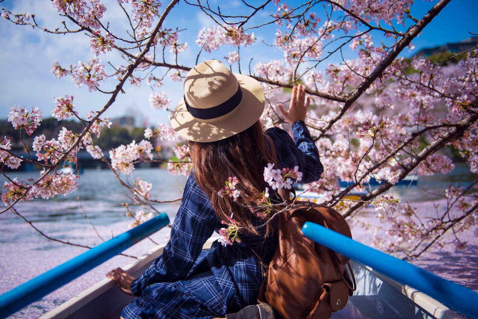
For further nature communing, you’d be remiss not to go on a boat ride at Chidorigafuchi, a moat linked to the palace complex. Visitors make a beeline to get on a 30-minute ride, with one person rowing and another busy with the camera. And why not? On a clear day, the cherry blossoms reflecting on the water’s surface, along with the glistening buildings of the metropolis rising in the distance, make this an experience like none other.
.map * {
font-family: sans-serif !important;
}
.info-window-link {
display: block;
margin-top: 10px;
padding: 3px 10px;
border-radius: 3px;
background-color: #0099ff;
color: white !important;
font-size: 12px;
text-align: center;
}
.info-window-link:hover {
text-decoration: none;
}
var _icons = {
red: {
url: ‘https://travelstoke.s3.amazonaws.com/assets/images/precise_marker_2x.png’,
size: { width: 22.8, height: 35.4 },
anchor: { x: 11.4, y: 35.4 }
},
orange: {
url: ‘https://travelstoke.s3.amazonaws.com/assets/images/precise_marker_orange_2x.png’,
size: { width: 22.8, height: 35.4 },
anchor: { x: 11.4, y: 35.4 }
},
yellow: {
url: ‘https://travelstoke.s3.amazonaws.com/assets/images/precise_marker_yellow_2x.png’,
size: { width: 22.8, height: 35.4 },
anchor: { x: 11.4, y: 35.4 }
}
};
var _styles = {
travelstoke: [
{
featureType: ‘administrative’,
elementType: ‘geometry.stroke’,
stylers: [{ color: ‘#999999’ }]
},
{
featureType: ‘landscape.natural.terrain’,
elementType: ‘geometry’,
stylers: [{ visibility: ‘off’ }]
},
{
featureType: ‘poi.business’,
elementType: ‘all’,
stylers: [{ visibility: ‘off’ }]
},
{
featureType: ‘road’,
elementType: ‘geometry.stroke’,
stylers: [{ color: ‘#ffffff’ }]
},
{
featureType: ‘water’,
elementType: ‘geometry’,
stylers: [{ color: ‘#53acce’ }]
}
],
desert: [{“elementType”:”labels”,”stylers”:[{“visibility”:”off”},{“color”:”#f49f53″}]},{“featureType”:”landscape”,”stylers”:[{“color”:”#f9ddc5″},{“lightness”:-7}]},{“featureType”:”road”,”stylers”:[{“color”:”#813033″},{“lightness”:43}]},{“featureType”:”poi.business”,”stylers”:[{“color”:”#645c20″},{“lightness”:38}]},{“featureType”:”water”,”stylers”:[{“color”:”#1994bf”},{“saturation”:-69},{“gamma”:0.99},{“lightness”:43}]},{“featureType”:”road.local”,”elementType”:”geometry.fill”,”stylers”:[{“color”:”#f19f53″},{“weight”:1.3},{“visibility”:”on”},{“lightness”:16}]},{“featureType”:”poi.business”},{“featureType”:”poi.park”,”stylers”:[{“color”:”#645c20″},{“lightness”:39}]},{“featureType”:”poi.school”,”stylers”:[{“color”:”#a95521″},{“lightness”:35}]},{},{“featureType”:”poi.medical”,”elementType”:”geometry.fill”,”stylers”:[{“color”:”#813033″},{“lightness”:38},{“visibility”:”off”}]},{},{},{},{},{},{},{},{},{},{},{},{“elementType”:”labels”},{“featureType”:”poi.sports_complex”,”stylers”:[{“color”:”#9e5916″},{“lightness”:32}]},{},{“featureType”:”poi.government”,”stylers”:[{“color”:”#9e5916″},{“lightness”:46}]},{“featureType”:”transit.station”,”stylers”:[{“visibility”:”off”}]},{“featureType”:”transit.line”,”stylers”:[{“color”:”#813033″},{“lightness”:22}]},{“featureType”:”transit”,”stylers”:[{“lightness”:38}]},{“featureType”:”road.local”,”elementType”:”geometry.stroke”,”stylers”:[{“color”:”#f19f53″},{“lightness”:-10}]},{},{},{}]
};
window.addEventListener(‘load’, function() {
console.log(‘test’);
jQuery(document).ready(function($) {
var boundPadding;
var id = ‘map-638afd0f6da40’;
var atts = {“lat”:”35.68833747797499″,”lng”:”139.75029962689146″,”zoom”:”16″};
var markers = [{“lat”:”35.6854189809771″,”lng”:”139.75281022659988″,”title”:”Imperial Palace”},{“lat”:”35.69031552805392″,”lng”:”139.74854009787072″,”title”:”Chidorigafuchi Moat”}];
var map = new google.maps.Map(document.getElementById(id), {
mapTypeId: google.maps.MapTypeId.ROADMAP,
disableDefaultUI: true,
zoomControl: true,
scrollwheel: false,
zoomControlOptions: {
style: google.maps.ZoomControlStyle.LARGE,
position: google.maps.ControlPosition.LEFT_CENTER
}
});
if (atts.style && _styles[atts.style])
map.setOptions({ styles: _styles[atts.style] });
if (atts.padding !== undefined)
boundPadding = parseInt(atts.padding);
var mapBounds;
if (atts.lat !== undefined && atts.lng !== undefined) {
// Use lat and lng if provided
map.setCenter({ lat: parseFloat(atts.lat), lng: parseFloat(atts.lng) });
} else if (markers && markers.length) {
if (markers.length === 1) {
// Use lat lng from first marker if only 1 provided
map.setCenter({ lat: parseFloat(markers[0].lat), lng: parseFloat(markers[0].lng) });
} else {
// With multiple markers create a boundry that includes all of them
mapBounds = new google.maps.LatLngBounds();
}
}
var labels = ‘ABCDEFGHIJKLMNOPQRSTUVWXYZ’;
var labelIndex = 0;
if(atts.offset !== undefined) {
labelIndex = parseInt(atts.offset);
}
var infoWindow = new google.maps.InfoWindow({ content: ” });
var openInfoWindow = function(marker, target) {
var info = $(‘
$(‘
if (marker.scroll_to) {
$(‘‘, {
class: ‘info-window-link’,
href: ‘#’ + marker.scroll_to,
}).append(‘Jump To’).appendTo(info);
}
infoWindow.setContent(info[0].outerHTML);
infoWindow.open({
anchor: target,
map: map,
shouldFocus: false
})
};
$(‘#’ + id).on(‘click’, ‘.info-window-link’, function(e) {
console.log(‘info window’);
e.preventDefault();
var target = $(e.target).attr(‘href’);
$(‘html, body’).animate({ scrollTop: $(target).offset().top – 55 }, 1000);
});
for (var i = 0; i < markers.length; i++) {
var marker = markers[i];
if (marker.lat !== undefined && marker.lng !== undefined) {
var markerObject = {
map: map,
position: { lat: parseFloat(marker.lat), lng: parseFloat(marker.lng) },
animation: google.maps.Animation.DROP,
locationId: i,
}
if(atts.ordered !== undefined) {
if(atts.numbered !== undefined) {
number = labelIndex = labelIndex + 1;
markerObject.label = number.toString();
} else {
markerObject.label = labels[labelIndex++ % labels.length];
}
}
if(marker.icon !== undefined) {
markerObject.icon = marker.icon;
}
var mapMarker = new google.maps.Marker(markerObject);
if (mapBounds) mapBounds.extend(mapMarker.getPosition());
if (marker.title) {
var infowindow = new google.maps.InfoWindow({ content: marker.title });
if (markers.length === 1) {
setTimeout(function() {
openInfoWindow(marker, mapMarker);
}, 1200);
}
google.maps.event.addListener(mapMarker, 'click', function() {
openInfoWindow(markers[this.locationId], this);
});
}
}
}
if (mapBounds) {
map.fitBounds(mapBounds, {top:boundPadding, right:boundPadding, left:boundPadding, bottom:boundPadding});
} else if (atts.zoom) {
map.setZoom(parseInt(atts.zoom));
} else {
map.setZoom(16);
}
});
});
Residents of the western suburb of Kichijoji may never feel the need to take the 20-minute subway ride into the heart of Tokyo. After all, their home turf is replete with neon lights, a variety of global cuisines, sushi bars for every budget, karaoke spots, endless options for shopping, and — most important for the purposes of this guide — one truly glorious park.
Inokashira Park has a lot to take in: a temple dedicated to the goddess Benzaiten, a large walking loop, a big pond reflecting fall colors, and swan-shaped paddleboats perfect for a solo traveler, a family with kids, or as a fun date activity. Spread across 95 acres, the century-old park was considered a gift from the emperor to the general public. As such, it continues to be treasured by the diverse residents of the neighborhood today.
If you’re traveling with your dog, this is a great stop to make, as there are frequent dog group meetups. And with a quiet cove every 200 meters or so, you’re never far from a bench to relax on.
Pick up an o-bento (lunch box) from the nearest store outside the park, which is slightly sunken from the level of the main road, thus adding to its allure of being disconnected from the city. If you’re looking for a sit-down meal with a view of the park, there are plenty of nearby options including sumptuous Thai cuisine and Italian fare.
.map * {
font-family: sans-serif !important;
}
.info-window-link {
display: block;
margin-top: 10px;
padding: 3px 10px;
border-radius: 3px;
background-color: #0099ff;
color: white !important;
font-size: 12px;
text-align: center;
}
.info-window-link:hover {
text-decoration: none;
}
var _icons = {
red: {
url: ‘https://travelstoke.s3.amazonaws.com/assets/images/precise_marker_2x.png’,
size: { width: 22.8, height: 35.4 },
anchor: { x: 11.4, y: 35.4 }
},
orange: {
url: ‘https://travelstoke.s3.amazonaws.com/assets/images/precise_marker_orange_2x.png’,
size: { width: 22.8, height: 35.4 },
anchor: { x: 11.4, y: 35.4 }
},
yellow: {
url: ‘https://travelstoke.s3.amazonaws.com/assets/images/precise_marker_yellow_2x.png’,
size: { width: 22.8, height: 35.4 },
anchor: { x: 11.4, y: 35.4 }
}
};
var _styles = {
travelstoke: [
{
featureType: ‘administrative’,
elementType: ‘geometry.stroke’,
stylers: [{ color: ‘#999999’ }]
},
{
featureType: ‘landscape.natural.terrain’,
elementType: ‘geometry’,
stylers: [{ visibility: ‘off’ }]
},
{
featureType: ‘poi.business’,
elementType: ‘all’,
stylers: [{ visibility: ‘off’ }]
},
{
featureType: ‘road’,
elementType: ‘geometry.stroke’,
stylers: [{ color: ‘#ffffff’ }]
},
{
featureType: ‘water’,
elementType: ‘geometry’,
stylers: [{ color: ‘#53acce’ }]
}
],
desert: [{“elementType”:”labels”,”stylers”:[{“visibility”:”off”},{“color”:”#f49f53″}]},{“featureType”:”landscape”,”stylers”:[{“color”:”#f9ddc5″},{“lightness”:-7}]},{“featureType”:”road”,”stylers”:[{“color”:”#813033″},{“lightness”:43}]},{“featureType”:”poi.business”,”stylers”:[{“color”:”#645c20″},{“lightness”:38}]},{“featureType”:”water”,”stylers”:[{“color”:”#1994bf”},{“saturation”:-69},{“gamma”:0.99},{“lightness”:43}]},{“featureType”:”road.local”,”elementType”:”geometry.fill”,”stylers”:[{“color”:”#f19f53″},{“weight”:1.3},{“visibility”:”on”},{“lightness”:16}]},{“featureType”:”poi.business”},{“featureType”:”poi.park”,”stylers”:[{“color”:”#645c20″},{“lightness”:39}]},{“featureType”:”poi.school”,”stylers”:[{“color”:”#a95521″},{“lightness”:35}]},{},{“featureType”:”poi.medical”,”elementType”:”geometry.fill”,”stylers”:[{“color”:”#813033″},{“lightness”:38},{“visibility”:”off”}]},{},{},{},{},{},{},{},{},{},{},{},{“elementType”:”labels”},{“featureType”:”poi.sports_complex”,”stylers”:[{“color”:”#9e5916″},{“lightness”:32}]},{},{“featureType”:”poi.government”,”stylers”:[{“color”:”#9e5916″},{“lightness”:46}]},{“featureType”:”transit.station”,”stylers”:[{“visibility”:”off”}]},{“featureType”:”transit.line”,”stylers”:[{“color”:”#813033″},{“lightness”:22}]},{“featureType”:”transit”,”stylers”:[{“lightness”:38}]},{“featureType”:”road.local”,”elementType”:”geometry.stroke”,”stylers”:[{“color”:”#f19f53″},{“lightness”:-10}]},{},{},{}]
};
window.addEventListener(‘load’, function() {
console.log(‘test’);
jQuery(document).ready(function($) {
var boundPadding;
var id = ‘map-638afd0f6dbb2’;
var atts = {“lat”:”35.69995662247485″,”lng”:”139.57371251056628″,”zoom”:”16″};
var markers = [{“lat”:”35.69995662247485″,”lng”:”139.57371251056628″,”title”:”Inokashira Park”}];
var map = new google.maps.Map(document.getElementById(id), {
mapTypeId: google.maps.MapTypeId.ROADMAP,
disableDefaultUI: true,
zoomControl: true,
scrollwheel: false,
zoomControlOptions: {
style: google.maps.ZoomControlStyle.LARGE,
position: google.maps.ControlPosition.LEFT_CENTER
}
});
if (atts.style && _styles[atts.style])
map.setOptions({ styles: _styles[atts.style] });
if (atts.padding !== undefined)
boundPadding = parseInt(atts.padding);
var mapBounds;
if (atts.lat !== undefined && atts.lng !== undefined) {
// Use lat and lng if provided
map.setCenter({ lat: parseFloat(atts.lat), lng: parseFloat(atts.lng) });
} else if (markers && markers.length) {
if (markers.length === 1) {
// Use lat lng from first marker if only 1 provided
map.setCenter({ lat: parseFloat(markers[0].lat), lng: parseFloat(markers[0].lng) });
} else {
// With multiple markers create a boundry that includes all of them
mapBounds = new google.maps.LatLngBounds();
}
}
var labels = ‘ABCDEFGHIJKLMNOPQRSTUVWXYZ’;
var labelIndex = 0;
if(atts.offset !== undefined) {
labelIndex = parseInt(atts.offset);
}
var infoWindow = new google.maps.InfoWindow({ content: ” });
var openInfoWindow = function(marker, target) {
var info = $(‘
$(‘
if (marker.scroll_to) {
$(‘‘, {
class: ‘info-window-link’,
href: ‘#’ + marker.scroll_to,
}).append(‘Jump To’).appendTo(info);
}
infoWindow.setContent(info[0].outerHTML);
infoWindow.open({
anchor: target,
map: map,
shouldFocus: false
})
};
$(‘#’ + id).on(‘click’, ‘.info-window-link’, function(e) {
console.log(‘info window’);
e.preventDefault();
var target = $(e.target).attr(‘href’);
$(‘html, body’).animate({ scrollTop: $(target).offset().top – 55 }, 1000);
});
for (var i = 0; i < markers.length; i++) {
var marker = markers[i];
if (marker.lat !== undefined && marker.lng !== undefined) {
var markerObject = {
map: map,
position: { lat: parseFloat(marker.lat), lng: parseFloat(marker.lng) },
animation: google.maps.Animation.DROP,
locationId: i,
}
if(atts.ordered !== undefined) {
if(atts.numbered !== undefined) {
number = labelIndex = labelIndex + 1;
markerObject.label = number.toString();
} else {
markerObject.label = labels[labelIndex++ % labels.length];
}
}
if(marker.icon !== undefined) {
markerObject.icon = marker.icon;
}
var mapMarker = new google.maps.Marker(markerObject);
if (mapBounds) mapBounds.extend(mapMarker.getPosition());
if (marker.title) {
var infowindow = new google.maps.InfoWindow({ content: marker.title });
if (markers.length === 1) {
setTimeout(function() {
openInfoWindow(marker, mapMarker);
}, 1200);
}
google.maps.event.addListener(mapMarker, 'click', function() {
openInfoWindow(markers[this.locationId], this);
});
}
}
}
if (mapBounds) {
map.fitBounds(mapBounds, {top:boundPadding, right:boundPadding, left:boundPadding, bottom:boundPadding});
} else if (atts.zoom) {
map.setZoom(parseInt(atts.zoom));
} else {
map.setZoom(16);
}
});
});
Head west out of the city and you’ll come to the Tama River, the course of which serves as a kind of gateway to a world of lush forests and mossy green riverside paths. This is a land of Buddhist retreats and sake breweries and represents a perfect escape from the bustle of central Tokyo. Welcome to Okutama.
There are hiking trails aplenty in the area, and every trail outing ought to be capped with a relaxing hour at an onsen — try Moegi-no-Yu, for example, where your skin will soak up the minerals while your ears take in the birdsong. For further relaxation, meditation at the Jigenji temple is an ideal way to start your morning, especially if you spend the night at a nearby inn.
Nature brings adrenaline to these Tokyo outskirts as well — there are opportunities for paddleboarding, kayaking, and even whitewater rafting. Do as the Tama River does and go with the flow, be it wild or easy. As you head back to the city, stop at the 150-year-old Ishikawa Brewery in Fussa, which, in addition to sake, also happens to brew its own craft beer.
.map * {
font-family: sans-serif !important;
}
.info-window-link {
display: block;
margin-top: 10px;
padding: 3px 10px;
border-radius: 3px;
background-color: #0099ff;
color: white !important;
font-size: 12px;
text-align: center;
}
.info-window-link:hover {
text-decoration: none;
}
var _icons = {
red: {
url: ‘https://travelstoke.s3.amazonaws.com/assets/images/precise_marker_2x.png’,
size: { width: 22.8, height: 35.4 },
anchor: { x: 11.4, y: 35.4 }
},
orange: {
url: ‘https://travelstoke.s3.amazonaws.com/assets/images/precise_marker_orange_2x.png’,
size: { width: 22.8, height: 35.4 },
anchor: { x: 11.4, y: 35.4 }
},
yellow: {
url: ‘https://travelstoke.s3.amazonaws.com/assets/images/precise_marker_yellow_2x.png’,
size: { width: 22.8, height: 35.4 },
anchor: { x: 11.4, y: 35.4 }
}
};
var _styles = {
travelstoke: [
{
featureType: ‘administrative’,
elementType: ‘geometry.stroke’,
stylers: [{ color: ‘#999999’ }]
},
{
featureType: ‘landscape.natural.terrain’,
elementType: ‘geometry’,
stylers: [{ visibility: ‘off’ }]
},
{
featureType: ‘poi.business’,
elementType: ‘all’,
stylers: [{ visibility: ‘off’ }]
},
{
featureType: ‘road’,
elementType: ‘geometry.stroke’,
stylers: [{ color: ‘#ffffff’ }]
},
{
featureType: ‘water’,
elementType: ‘geometry’,
stylers: [{ color: ‘#53acce’ }]
}
],
desert: [{“elementType”:”labels”,”stylers”:[{“visibility”:”off”},{“color”:”#f49f53″}]},{“featureType”:”landscape”,”stylers”:[{“color”:”#f9ddc5″},{“lightness”:-7}]},{“featureType”:”road”,”stylers”:[{“color”:”#813033″},{“lightness”:43}]},{“featureType”:”poi.business”,”stylers”:[{“color”:”#645c20″},{“lightness”:38}]},{“featureType”:”water”,”stylers”:[{“color”:”#1994bf”},{“saturation”:-69},{“gamma”:0.99},{“lightness”:43}]},{“featureType”:”road.local”,”elementType”:”geometry.fill”,”stylers”:[{“color”:”#f19f53″},{“weight”:1.3},{“visibility”:”on”},{“lightness”:16}]},{“featureType”:”poi.business”},{“featureType”:”poi.park”,”stylers”:[{“color”:”#645c20″},{“lightness”:39}]},{“featureType”:”poi.school”,”stylers”:[{“color”:”#a95521″},{“lightness”:35}]},{},{“featureType”:”poi.medical”,”elementType”:”geometry.fill”,”stylers”:[{“color”:”#813033″},{“lightness”:38},{“visibility”:”off”}]},{},{},{},{},{},{},{},{},{},{},{},{“elementType”:”labels”},{“featureType”:”poi.sports_complex”,”stylers”:[{“color”:”#9e5916″},{“lightness”:32}]},{},{“featureType”:”poi.government”,”stylers”:[{“color”:”#9e5916″},{“lightness”:46}]},{“featureType”:”transit.station”,”stylers”:[{“visibility”:”off”}]},{“featureType”:”transit.line”,”stylers”:[{“color”:”#813033″},{“lightness”:22}]},{“featureType”:”transit”,”stylers”:[{“lightness”:38}]},{“featureType”:”road.local”,”elementType”:”geometry.stroke”,”stylers”:[{“color”:”#f19f53″},{“lightness”:-10}]},{},{},{}]
};
window.addEventListener(‘load’, function() {
console.log(‘test’);
jQuery(document).ready(function($) {
var boundPadding;
var id = ‘map-638afd0f6dd29’;
var atts = {“lat”:”35.774705052819″,”lng”:”139.25155895150846″,”zoom”:”11″};
var markers = [{“lat”:”35.80650318187564″,”lng”:”139.09233262156346″,”title”:”Okutama”},{“lat”:”35.719426192031825″,”lng”:”139.33257554009444″,”title”:”Ishikawa sake brewery”},{“lat”:”35.805521126396044″,”lng”:”139.1026559153413″,”title”:”Moegi-no-Yu onsen”},{“lat”:”35.799803955589326″,”lng”:”139.0875749013275″,”title”:”Jigenji temple”}];
var map = new google.maps.Map(document.getElementById(id), {
mapTypeId: google.maps.MapTypeId.ROADMAP,
disableDefaultUI: true,
zoomControl: true,
scrollwheel: false,
zoomControlOptions: {
style: google.maps.ZoomControlStyle.LARGE,
position: google.maps.ControlPosition.LEFT_CENTER
}
});
if (atts.style && _styles[atts.style])
map.setOptions({ styles: _styles[atts.style] });
if (atts.padding !== undefined)
boundPadding = parseInt(atts.padding);
var mapBounds;
if (atts.lat !== undefined && atts.lng !== undefined) {
// Use lat and lng if provided
map.setCenter({ lat: parseFloat(atts.lat), lng: parseFloat(atts.lng) });
} else if (markers && markers.length) {
if (markers.length === 1) {
// Use lat lng from first marker if only 1 provided
map.setCenter({ lat: parseFloat(markers[0].lat), lng: parseFloat(markers[0].lng) });
} else {
// With multiple markers create a boundry that includes all of them
mapBounds = new google.maps.LatLngBounds();
}
}
var labels = ‘ABCDEFGHIJKLMNOPQRSTUVWXYZ’;
var labelIndex = 0;
if(atts.offset !== undefined) {
labelIndex = parseInt(atts.offset);
}
var infoWindow = new google.maps.InfoWindow({ content: ” });
var openInfoWindow = function(marker, target) {
var info = $(‘
$(‘
if (marker.scroll_to) {
$(‘‘, {
class: ‘info-window-link’,
href: ‘#’ + marker.scroll_to,
}).append(‘Jump To’).appendTo(info);
}
infoWindow.setContent(info[0].outerHTML);
infoWindow.open({
anchor: target,
map: map,
shouldFocus: false
})
};
$(‘#’ + id).on(‘click’, ‘.info-window-link’, function(e) {
console.log(‘info window’);
e.preventDefault();
var target = $(e.target).attr(‘href’);
$(‘html, body’).animate({ scrollTop: $(target).offset().top – 55 }, 1000);
});
for (var i = 0; i < markers.length; i++) {
var marker = markers[i];
if (marker.lat !== undefined && marker.lng !== undefined) {
var markerObject = {
map: map,
position: { lat: parseFloat(marker.lat), lng: parseFloat(marker.lng) },
animation: google.maps.Animation.DROP,
locationId: i,
}
if(atts.ordered !== undefined) {
if(atts.numbered !== undefined) {
number = labelIndex = labelIndex + 1;
markerObject.label = number.toString();
} else {
markerObject.label = labels[labelIndex++ % labels.length];
}
}
if(marker.icon !== undefined) {
markerObject.icon = marker.icon;
}
var mapMarker = new google.maps.Marker(markerObject);
if (mapBounds) mapBounds.extend(mapMarker.getPosition());
if (marker.title) {
var infowindow = new google.maps.InfoWindow({ content: marker.title });
if (markers.length === 1) {
setTimeout(function() {
openInfoWindow(marker, mapMarker);
}, 1200);
}
google.maps.event.addListener(mapMarker, 'click', function() {
openInfoWindow(markers[this.locationId], this);
});
}
}
}
if (mapBounds) {
map.fitBounds(mapBounds, {top:boundPadding, right:boundPadding, left:boundPadding, bottom:boundPadding});
} else if (atts.zoom) {
map.setZoom(parseInt(atts.zoom));
} else {
map.setZoom(16);
}
});
});
Untamed landscapes await you on the Izu Islands. This string of islets falls within Tokyo prefecture and yet calls for a boat ride of a few hours or an hour-long plane ride to reach. The tropical hideaways have everything your mood fancies: surf spots, colorful coral reefs, hiking trails, and clear nights with impressive stargazing.
Niijima, also called “Surf Island,” has 10 surfing beaches and a free campground. New to surfing? No problem! Rent a board and take lessons at one of the many surf shops on the island. Or, rent a bicycle and pedal around the island to check out the local glass art and intriguing statues.
If you want to break a sweat before taking a dip in the ocean, try one of the hiking trails around Mount Mihara on Oshima. Movie buffs will recall that this volcano woke Godzilla from his deep slumber; those more geologically motivated will enjoy the local museum.
The farthest of the Izu Islands — and most challenging to reach — is Aogashima. The helicopter ride is well worth the yen spent. After climbing Maruyama, the island’s inner crater, relax in the volcano-powered sauna and sip the locally brewed sweet-potato alcohol while looking forward to a morning meal of fresh local produce. All this in Tokyo? Now that’s an escape. ![]()
.map * {
font-family: sans-serif !important;
}
.info-window-link {
display: block;
margin-top: 10px;
padding: 3px 10px;
border-radius: 3px;
background-color: #0099ff;
color: white !important;
font-size: 12px;
text-align: center;
}
.info-window-link:hover {
text-decoration: none;
}
var _icons = {
red: {
url: ‘https://travelstoke.s3.amazonaws.com/assets/images/precise_marker_2x.png’,
size: { width: 22.8, height: 35.4 },
anchor: { x: 11.4, y: 35.4 }
},
orange: {
url: ‘https://travelstoke.s3.amazonaws.com/assets/images/precise_marker_orange_2x.png’,
size: { width: 22.8, height: 35.4 },
anchor: { x: 11.4, y: 35.4 }
},
yellow: {
url: ‘https://travelstoke.s3.amazonaws.com/assets/images/precise_marker_yellow_2x.png’,
size: { width: 22.8, height: 35.4 },
anchor: { x: 11.4, y: 35.4 }
}
};
var _styles = {
travelstoke: [
{
featureType: ‘administrative’,
elementType: ‘geometry.stroke’,
stylers: [{ color: ‘#999999’ }]
},
{
featureType: ‘landscape.natural.terrain’,
elementType: ‘geometry’,
stylers: [{ visibility: ‘off’ }]
},
{
featureType: ‘poi.business’,
elementType: ‘all’,
stylers: [{ visibility: ‘off’ }]
},
{
featureType: ‘road’,
elementType: ‘geometry.stroke’,
stylers: [{ color: ‘#ffffff’ }]
},
{
featureType: ‘water’,
elementType: ‘geometry’,
stylers: [{ color: ‘#53acce’ }]
}
],
desert: [{“elementType”:”labels”,”stylers”:[{“visibility”:”off”},{“color”:”#f49f53″}]},{“featureType”:”landscape”,”stylers”:[{“color”:”#f9ddc5″},{“lightness”:-7}]},{“featureType”:”road”,”stylers”:[{“color”:”#813033″},{“lightness”:43}]},{“featureType”:”poi.business”,”stylers”:[{“color”:”#645c20″},{“lightness”:38}]},{“featureType”:”water”,”stylers”:[{“color”:”#1994bf”},{“saturation”:-69},{“gamma”:0.99},{“lightness”:43}]},{“featureType”:”road.local”,”elementType”:”geometry.fill”,”stylers”:[{“color”:”#f19f53″},{“weight”:1.3},{“visibility”:”on”},{“lightness”:16}]},{“featureType”:”poi.business”},{“featureType”:”poi.park”,”stylers”:[{“color”:”#645c20″},{“lightness”:39}]},{“featureType”:”poi.school”,”stylers”:[{“color”:”#a95521″},{“lightness”:35}]},{},{“featureType”:”poi.medical”,”elementType”:”geometry.fill”,”stylers”:[{“color”:”#813033″},{“lightness”:38},{“visibility”:”off”}]},{},{},{},{},{},{},{},{},{},{},{},{“elementType”:”labels”},{“featureType”:”poi.sports_complex”,”stylers”:[{“color”:”#9e5916″},{“lightness”:32}]},{},{“featureType”:”poi.government”,”stylers”:[{“color”:”#9e5916″},{“lightness”:46}]},{“featureType”:”transit.station”,”stylers”:[{“visibility”:”off”}]},{“featureType”:”transit.line”,”stylers”:[{“color”:”#813033″},{“lightness”:22}]},{“featureType”:”transit”,”stylers”:[{“lightness”:38}]},{“featureType”:”road.local”,”elementType”:”geometry.stroke”,”stylers”:[{“color”:”#f19f53″},{“lightness”:-10}]},{},{},{}]
};
window.addEventListener(‘load’, function() {
console.log(‘test’);
jQuery(document).ready(function($) {
var boundPadding;
var id = ‘map-638afd0f6deb5’;
var atts = {“lat”:”33.53220389137506″,”lng”:”139.64372929918966″,”zoom”:”7″};
var markers = [{“lat”:”34.37724914745923″,”lng”:”139.26868335585272″,”title”:”Niijima”},{“lat”:”34.746238185671736″,”lng”:”139.38593621315366″,”title”:”Oshima”},{“lat”:”32.45219819166835″,”lng”:”139.7648056642986″,”title”:”Aogashima”}];
var map = new google.maps.Map(document.getElementById(id), {
mapTypeId: google.maps.MapTypeId.ROADMAP,
disableDefaultUI: true,
zoomControl: true,
scrollwheel: false,
zoomControlOptions: {
style: google.maps.ZoomControlStyle.LARGE,
position: google.maps.ControlPosition.LEFT_CENTER
}
});
if (atts.style && _styles[atts.style])
map.setOptions({ styles: _styles[atts.style] });
if (atts.padding !== undefined)
boundPadding = parseInt(atts.padding);
var mapBounds;
if (atts.lat !== undefined && atts.lng !== undefined) {
// Use lat and lng if provided
map.setCenter({ lat: parseFloat(atts.lat), lng: parseFloat(atts.lng) });
} else if (markers && markers.length) {
if (markers.length === 1) {
// Use lat lng from first marker if only 1 provided
map.setCenter({ lat: parseFloat(markers[0].lat), lng: parseFloat(markers[0].lng) });
} else {
// With multiple markers create a boundry that includes all of them
mapBounds = new google.maps.LatLngBounds();
}
}
var labels = ‘ABCDEFGHIJKLMNOPQRSTUVWXYZ’;
var labelIndex = 0;
if(atts.offset !== undefined) {
labelIndex = parseInt(atts.offset);
}
var infoWindow = new google.maps.InfoWindow({ content: ” });
var openInfoWindow = function(marker, target) {
var info = $(‘
$(‘
if (marker.scroll_to) {
$(‘‘, {
class: ‘info-window-link’,
href: ‘#’ + marker.scroll_to,
}).append(‘Jump To’).appendTo(info);
}
infoWindow.setContent(info[0].outerHTML);
infoWindow.open({
anchor: target,
map: map,
shouldFocus: false
})
};
$(‘#’ + id).on(‘click’, ‘.info-window-link’, function(e) {
console.log(‘info window’);
e.preventDefault();
var target = $(e.target).attr(‘href’);
$(‘html, body’).animate({ scrollTop: $(target).offset().top – 55 }, 1000);
});
for (var i = 0; i < markers.length; i++) {
var marker = markers[i];
if (marker.lat !== undefined && marker.lng !== undefined) {
var markerObject = {
map: map,
position: { lat: parseFloat(marker.lat), lng: parseFloat(marker.lng) },
animation: google.maps.Animation.DROP,
locationId: i,
}
if(atts.ordered !== undefined) {
if(atts.numbered !== undefined) {
number = labelIndex = labelIndex + 1;
markerObject.label = number.toString();
} else {
markerObject.label = labels[labelIndex++ % labels.length];
}
}
if(marker.icon !== undefined) {
markerObject.icon = marker.icon;
}
var mapMarker = new google.maps.Marker(markerObject);
if (mapBounds) mapBounds.extend(mapMarker.getPosition());
if (marker.title) {
var infowindow = new google.maps.InfoWindow({ content: marker.title });
if (markers.length === 1) {
setTimeout(function() {
openInfoWindow(marker, mapMarker);
}, 1200);
}
google.maps.event.addListener(mapMarker, 'click', function() {
openInfoWindow(markers[this.locationId], this);
});
}
}
}
if (mapBounds) {
map.fitBounds(mapBounds, {top:boundPadding, right:boundPadding, left:boundPadding, bottom:boundPadding});
} else if (atts.zoom) {
map.setZoom(parseInt(atts.zoom));
} else {
map.setZoom(16);
}
});
});
2 thoughts on “6 Hidden Nature Escapes in Tokyo”
Leave a Comment

Your point of view caught my eye and was very interesting. Thanks. I have a question for you. https://www.binance.info/en/join?ref=IJFGOAID
Can you be more specific about the content of your article? After reading it, I still have some doubts. Hope you can help me.